Tuesday, June 15, 2021

Once Brewed to Bellingham: LEJoG Day 42

The day started with a walk along Hadrian's Wall, then it was rough upland pastures and commercial forestry.

Having ordered breakfast I set off for the dining area only to realise I had forgotten my face mask, needed to meet Covid requirements, so a return to my bedroom was needed before I could tuck into a full English.

Masonry of Hadrian's Wall with small fern.

Leaving the Youth Hostel I joined many others walking along Hadrian's Wall. Strategically located, often on a cliff top, with extensive areas visible to the north, beyond the boundary of the Roman Empire. After a mile post, a watchtower and some steep ascents and descents I headed north on the Pennine Way from a gap in the long ridge on which the wall stands. Or so I thought, after a little way I realised two footpaths left the gap, and I was on the wrong one, a correction was required. From then on I paid better attention to my GPS, extending my lead on the couple behind me but losing sight of the two men ahead of me. A farmer on his quad bike, told me he was seeing more walkers on the Pennine Way this year. The reason I suggested, was because lockdown restrictions had forced people to stay near home for many months, so they were desperate to cover some ground now restrictions on travel in the UK had been lifted. Alternatively the continuing restrictions on international travel forced people to walk in Britain. 

Walking North beyond Hadrian's Wall, moors and forestry.

Brown Bugle.

After some fields of rough grazing I entered part of the Kielder Forest, a huge area of commercial forestry dominated by Sikta spruce, a fast growing conifer, but with the occasional Rowan tree sneaking in. Most of the route was on a path through the trees, muddy and wet in place, although there were some interesting flowers such as brown bugle. Seeing a sign for a look out, I followed a side path to see the view. Unfortunately saplings spoilt any vista. I sat down to have a snack but a huge number of tiny midges arrived to snack on me! I hastily packed and left. Later, after leaving the forest I noticed a sign by a farmhouse offering hot and cold drinks and snacks. An outhouse contained the "Pit Stop" where I helped myself to a black coffee and a kitkat from the fridge and in return put a few coins in the tin for donations. It made a welcome break and although some of the seating was not very clean there was plastic seating outside. I have read about such kindness by "Trail Angels" on the Appalachian Trail and other US mega trails, but it is uncommon here in the UK, where maybe we are more suspicious of others. 

Cows beside the trail.

Helpful boardwalks over marshy areas.

After a few hours of walking over moors or rough pasture I crested a ridge and saw the small town if Bellingham ahead of me. The cheerful and helpful man at the Camping and Caravan Club campsite went through a comprehensive description of the measures taken to combat Coronavirus including a system of green or red computer displays telling you if you can enter the toilets and a request to spray disinfectant around touch surfaces when you have finished. I am now very full after three courses at "The Cheviot". My waistline has expanded. 

River North Tyne in the evening light on my return from my meal at "The Cheviot".


Monday, June 14, 2021

Alston to Once Brewed: LEJoG Day 41

A long day's hike of three parts, first, an old railway line, second, a moorland section and thirdly, Hadrian's Wall.

Today I decided to walk a lengthy 38 kilometres to reach the Once Brewed Youth Hostel. Tomorrow's hike will be shorter as a result. Consequently I started off early, before my Bed & Breakfast was offering Breakfast. Instead I picked up a coffee at the nearby convenience store but did not risk the fatty looking bacon butties. Forgetting my face mask, which you must wear in shops and other enclosed spaces due to the Coronavirus, I had to return to my hotel room to retrieve it before I could buy my coffee which rather delayed me and maybe caused me to utter a few swear words.

Guides are generally agreed that the walk to Greenhead from Alston is the least attractive stretch of the Pennine Way, but for part of it there is an alternative, the River Tyne Trail. I followed this trail as far as I could which was to Lambley. The trail follows the path of an old railway line. Near Alston a narrow gauge heritage railway is in operation (or would be if it was not for the Coronavirus restrictions). I followed the path beside the line which extended to the village of Slaggyford, after which I had the bed of the old railway to myself. I enjoyed the fast, flat walking and the avenues of birch trees. A sign marked the point I crossed from Cumberland (a county which no longer exists) to Northumberland. At Lambley there was also a tall, multi-arched, stone viaduct across the valley to admire.

Birch trees lining my path along an old railway line.

Regretfully leaving the South Tyne Trail, I followed a section of road to re-join the Pennine Way. Rising up and down across the moors, by fluffy white cotton sedge, I walked alone listening to the cries of Curlews and Lapwings. Close to Greenhead I left the Pennine Way on a little used footpath to visit the centre of the village which the official route avoids. My reason was to visit the Greenhead tea room for a spot of lunch.

Lonely stile in the moors.

Leaving the village on a path between a river and a functioning railway line I reached the Pennine Way by Thirlwall Castle. A few walls remain of this 14th century fortified manor house. Within them a group of younger people with rucksacks were enjoying a rest. After I set off they soon past me at speed, one of them was playing music with a suitable beat for walking to as they disappeared over the hill. I consoled myself that their smell of after-shave or deodorant suggested they had not walked the 26 kilometres I had already covered. They stopped at the kiosk at the next carpark where I passed them, never to see them again.

There were plenty of other people on the next section of trail which runs beside Hadrian's Wall. In addition to people visiting for the day, two National Trails follow this section, the Pennine Way and Hadrian's Wall Path. Some were struggling a little with the steep up and downhill stretches. Hadrian's Wall in this area follows the top of a cliff which faces north, making it an excellent defensive position against any attacks from the lands yet to be conquered by the Romans. The cliff is formed by the Whin Sill, a layer of igneous rock called dolerite which gently dips towards the south, formed by the intrusion of molten magma between layers of sedimentary rocks. The dolerite was quarried for road stone, and the route went through two former quarries. In my memory from my last trip there was more of the wall remaining, but what I saw today provoked my imagination with thoughts of Roman soldiers, maybe from Southern Europe, patrolling the walls day after day, maybe shivering in the cold as they looked out over bleak moors and grey clouds to the north, wishing for a bit of action to break the tedium. Then again maybe the land was wooded rather than moorland at the time.

Walking beside Hadrian's Wall.

My arrival at the road leading to the Youth Hostel put an end to my reverie. "The Sill" hostel is a new structure. Sparsely modern with glass and white paint, a contrast to the "Once Brewed" hostel it replaced which I stayed at seven or eight years ago, and thought perfectly adequate. The hostel is by the Twice Brewed Inn. According to one source so called as the beer was so weak some General demanded it should be brewed twice. A benefactor for the youth hostel when it was first built was teetotal and thought Once Brewed was quite enough, hence the name given to the hostel I previously stayed in. I guess "The Sill" was thought a more modern name than Once Brewed. Whatever the reasons I ate at the hostel and, deciding to have a night off alcohol, just drank a ginger beer. 


Sunday, June 13, 2021

Dufton to Alston: LEJoG Day 40

Four mountains today, but there was little to see as they were hidden in cloud.

Today started well as the Pennine Way wound between walls on a flower lined path, overhung with hawthorn blossom. Then the climbing started. A long pull up a track then a footpath. As I passed the 500 metre contour I entered the clouds. Soon visibility was down to 10 metres. I was glad of my GPS as in places today the path was not visible on the ground, and signs were few, although a few large cairns had been constructed. Knock Fell was the first mountain but the next one, Great Dun Fell, was of greater interest as there were a few radar domes and aerials on the top for air traffic control. Two cyclists were inside the fence that surrounded the installation, I am sure they should not have been there. According to Wikipedia the summit is in cloud for two thirds of the time, so it was unsurprising that I found it in that state today. Little Dun Fell followed and then the highest summit on the Pennines, Cross Fell. I briefly stopped at the sheltered benches at the top with another walker but there was little to keep me.

Other walkers appearing through the mist.

Climbing down from Cross Fell I dropped below the clouds. As I walked along the track, clouds blew across me and raced over the open moors which extended far into the distance. 

Track down to Garrigill.

Walking down to the village of Garrigill took a long time, longer than I had thought or hoped. I passed Greg's hut, one of the few bothies on the Pennine Way, there was not much in it last time I visited so I just kept going. Occasional cyclists and ramblers said hello as we briefly came within speaking distance. Heaps of rocks, collapsed walls of small buildings and a mine shaft, filled with rubbish, attested to the former mining operations. On the ground I spotted small crystals of purply fluorite by the spoil heaps. A few lapwings were excited by my passing. 

Garrigill was a sweet village of stone built houses around a triangular green. I had hoped for a tea shop, but there was none and the George and Dragon pub did not look like it would ever open again (although bonus points for the public toilets). For the final stretch into Alston the path followed the River South Tyne as it splashed over ledges of rock. Initially there were meadows and paths through many types of flower. Later I crossed fields closely observed by sheep and cows.

Flowers by path into Alston.

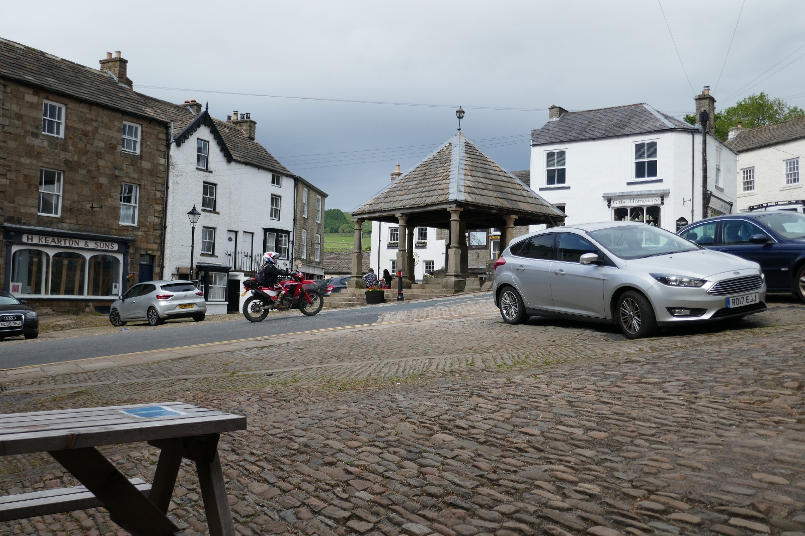
Reaching Alston village I quickly found a tea shop and bought a coffee and muffin just before it closed, enjoying them at a table outside watching motorbikes race through the square. Now I am in the Cumberland hotel, one of the many pubs in Alston. Other tables are occupied by cyclists doing their version of the coast to coast, a couple I am sure I passed on the Pennine Way and a table with two couples. One of these couples dominated the conversation with husband and wife both trying to lead the narrative on subjects as diverse as the Aberdeen cruise ship harbour, relatives in Texas, and Labour party leaders. As you can surmise they were not especially quiet...

Market square in Alston.

Saturday, June 12, 2021

Middleton in Teesdale to Dufton: LEJoG Day 39

Several scenic sights today, in particular the waterfalls of Low Force, High Force and Cauldron Snout, followed by Nick's Cup.

In contrast to recent days crossing high, open moors, this morning was spent walking beside the River Tees. Hay meadows seemed to have a greater variety of flowers than earlier on my trip, not just buttercups, and where the path was close to the tree lined river there were bluebells, yellow ladies bedstraw, geraniums and many others. Brown water raced over rocks in the river, with rapids and minor cascades over ledges. There were two major waterfalls, Low Force and further up river, the impressive High Force, where water fell 21 metres over a cliff of harder igneous rocks, framed by trees.

High Force.

Continuing up the Pennine Way, moving from farmed to moorland landscape, I caught up with a group of bird watchers. Asking about a whistling I could hear from the other side of the river, I was told it was a common sandpiper. They stood aside as I passed, hoping from boulder to boulder beneath the scree and cliffs beside the river.

Cauldron Snout was an impressive, white foaming cascade falling over and between rocks beneath the Cow Green reservoir. I had fun climbing up those rocks on a well worn route, the only place on the Pennine Way where you need to use your hands as well as your feet. Many people were enjoying the sight, including a fellow Pennine Way walker who I was frequently meeting at campsites or on the trail.
A long uphill slog followed, feeling longer as the wind was blowing against me and because I had not anticipated its length. In the river the track was following an aristocratic fly fishermen caught a fish just as I passed, his assistant hurried to detach it from the hook. Scruffy, shaggy sheep looked at me as I passed. Wool prices are apparently too low to cover the cost of shearing them, so they loose their thick winter coat in chunks, rubbing against posts and rocks to remove it. Their lambs by contrast look neat in trim, curly white coats.

Eventually I crossed the watershed and reached High Cup. On my last trip down the Pennine Way I walked this way in dense cloud, with compass navigation, unable to see more than ten metres away. This time I could see far into the distance, beyond the perfect "U" of the valley that formed High Cup, across farmed fields to distant mountains. The Cup itself is a feature formed by a glacier with a steep backwall and steep sides above the curved valley bottom. 

High Cup.

Then it was along the edge of the Cup and downhill in intermittent sunshine into Dufton, a small village built with red sandstone. The caravan site has a length of grass for backpacking and cycling campers where a group of us have pitched our tents. Although the Stag Inn was busy this Saturday night, thankfully they still had room to feed me.

Hawthorn blossom.


Friday, June 11, 2021

Tan Hill to Middleton in Teesdale: LEJoG Day 38

Another day crossing moors.

Overnight the wind had been strong. My tent constantly flapped in and out with varying ferocity. Having made sure the pegs were firmly in I was not too worried, the tent had seen similar weather before. However, once I had woken at 6:00 am, the general commotion encouraged me to make an early start. I was surprised the other tents pitched by the Inn had survived so well, most belonging to a group of motor bikers, only one seems to have been abandoned overnight.

Morning view on start of walk from Tan Hill.

Many hours of walking over the moors followed, pushed along by the strong breeze. This section of the Pennine Way had not been improved, there were no paving slabs so there was a bit of wet, peaty mud and the path was indistinct among the moss in places. Lapwings were much in evidence, there were birds I failed to identify, although I recognised Oyster Catchers, some distance from the sea. There was an optional loop to the village of Bowes, if I had known there was a coffee shop open there I might have been tempted, as it was I took the main route which crossed a natural bridge over a brook. After some grouse shooting butts I reached a black painted rectangular building within which the owner had kindly provided a shelter for hikers from the wind. I took advantage of it for a snack. The back wall was full of people's scribbled comments. They commented that we were at the halfway point on the Pennine Way, as well as the number of blisters they had and made existential comments on why they were doing it.

More moors.

A later sight near some reservoirs stacked up in a valley was Hannah's Meadow, full of buttercups. Hannah was a farmer living without electricity or running water who appeared on a television program. Unlike many farms her fields were not intensively farmed so the traditional flower meadows remained and are now preserved. A documentary about the difficulties of upland farming called "Too Long a Winter" was also filmed here. In today's wind and intermittent drizzle the area looked bleak, however on lower ground the sun occasionally lit up fields of yellow buttercups. There were so many buttercups it was almost as if the farmers were cultivating them, although if you looked closely there were also forget-me-nots, clover, daisies, grass and other plants.

Fields of buttercups.

It's always nice to find unexpected treats, so I was pleased to find a "tuck box". Sweets and cans of soft drink were in the box, you took one and left the money in an honesty box. I was enjoying a Coke when the lady of the house passed by, apparently the tuck box was her enterprising daughter's idea. She told me about the "Spine Race" in which runner's complete the Pennine Way in as little as four days! I was finding just walking it quite enough.

I am camped at Daleview campsite a little outside Middleton-in-Teesdale, a traditional village of stone built houses. I was recommended the Teesdale hotel for an evening meal and am full of seafood chowder; pork, apple and black pudding pie, and summer fruit, peanut butter crumble.....lovely. 


Thursday, June 10, 2021

Hawes to Tan Hill: LEJoG Day 37

A day crossing the fells partly in cloud.

My day began with a continental breakfast at the Youth Hostel. There were only five people staying, including myself, which gave the cook time to arrange a variety of fruit slices for my breakfast in an exceedingly artistic display.

Setting off across fields I saw signs inviting people to a sheepdog demonstration later that day, which made me wish I was staying longer. Another temptation to delay was the tea room in the village of Hardraw, I could see the cakes through the window. However, still full from breakfast I instead started on the long climb up Shunner Fell. On the way there was a stone barns similar to others I had seen, and admired in the area. It looked like they had been built without cement between the flagstones of which they were constructed. 

Stone barn typical of Yorkshire Dales in field of buttercups.

No rain had been forecast for today but the overcast sky with waves of grey clouds suggested otherwise. Amid a slight drizzle I looked up to where the path was lost in cloud, couples just visible in the distance climbing ever higher. Lapwings flew above me squeaking as I entered moorland in which a sign stated that heather and black grouse were being encouraged, although rough grass and moss seem to predominate. A few small brown birds ran away from me as I passed.

Crossing Great Shunner Fell.

There were several people walking the path today, I pointed out to one couple imprints of Carboniferous period trees on the rocks we were crossing. Another I had met before, they were walking the Pennine Way at a similar pace to me. I saw their orange, rucksack rain covers in the distance and gradually caught up with them. We swapped stories of long distance walks and how we had planned them in lockdown, as well as discussing knee ailments. 

The summit of Shunner Fell was wrapped in mist, two couples were having snacks on benches protected from the wind by a stone construction. I did not stop as I planned to patronise a tea shop in Thwaite or Keld. The one in the stone village of Thwaite came first. Motor bikers, walkers and local people were  keeping the staff busy, but they still managed me a latte and a slice of fruit cake served with Wensleydale cheese (although I think I was now in Swaledale).

The Pennine Way climbed the valley side before dropping down to a scenic river and waterfalls among trees by Keld. Another long climb into the moorland took me to the Tan Hill Inn. 

Tan Hill Inn.

The Tan Hill Inn will be known to all walkers on the Pennine Way. It is a remote pub, high in the fells, so high it is the highest pub in the British Isles. It once served a mining community that has long gone, now it serves tourists and hikers. I was here several years ago, and it was a charming if slightly ramshackle affair. For many years it was run by a welcoming lady, but in 2018 it changed ownership. The bed & breakfast rooms have been upgraded and were now beyond the price range of most Pennine Way walkers, indeed the high prices were the talk of the trail. I was camping but had booked for dinner, wise as it was busy with waiting staff scurrying around, however the food was delivered promptly. As the evening progressed and the diner rush ended, things relaxed and there was an "open mike" night, although my enjoyment of the singing was slightly spoilt by the unending chatter of two men on the next table (the wife was ignored). How do people find so much that they must talk about?

Wednesday, June 9, 2021

Horton in Ribblesdale to Hawes: LEJoG Day 36

A walk on good tracks over upland pasture followed by a visit to the Yorkshire Wensleydale cheese factory. 

Backpackers often compare "gear". This morning a fellow camper came over and commented on my Terra Nova Laser Compact Tent (designed in Derbyshire) versus his Swedish Hilleberg (Hilleberg owners always think their tents are the best), and his American Gossamer Gear stayless rucksack versus my single stay Atom Pack (sewn in the Lake District). Then I went for a full English breakfast in the Golden Lion pub.

Today's walk was across the high fells, rough grass dotted with sheep, pasture bordered by dry stone walls topped by lines of barbed wire. Few buildings were visible but looking down into the folds of the landscape, in the distant valley bottoms there were a few small farmsteads among stands of trees. 

Pennine Way running between drystone walls.

Stream disappearing into a cave.

Early on, a brook disappeared down a deep gash in the limestone which had surfaced out of the grass. Peering down into the depths, passed ferns growing from the rocks, a cave system seemed be accepting the flow. Long Gill was a deep, tree lined gorge slashed through the landscape. On the rocks at the top a bird, a dipper I think, performed a little dance for me, looking one way and then the other, its wings like a ballerina's arms.

As the track was good, easy walking on some ancient trails, I reached my destination of Hawes unexpectedly early. It gave an opportunity to visit the Wensleydale Creamery, first the coffee shop and then the "Wensleydale experience" which explained the history and process of making the Dale's most famous product. Wallace and Gromit, celebrity lovers of Wensleydale cheese, would have been impressed.

Making Wensleydale cheese.

Tonight I am staying at the Hawes Youth Hostel at the edge of town. As the largest town for a while I mingled with the tourist crowds to replenish my supplies. As always I bought too much, a weight I now have to carry for several days!

Thoughts on Land's End to John o'Groats trail

Walking the length of the British Isles between its most distant points, from Land's End to John o'Groats, could require covering as...